This will include entries for every orienteering event I compete in, as well as a few other orienteering-related occasions which didn't involve a competitive run. You may well be wondering "why?", but you're obviously at least vaguely interested to have visited in the first place... I've written it primarily to aid my own memory, though I'm also trying to point out the types of problems that can occur at events, both those during running the course and those to do with the organisation, in the hope that anyone who has read them here will not repeat them! The most recent entries come first in the list.
Note: regular visitors (if there are any) will notice the lack of new entries since I got a job... I do intend to bring this site up to date eventually, but it may be some time in the future!
Jan 04 Feb 04 Mar 04 Apr 04 May 04 Jun 04 Jul 04 Aug 04 Sep 04
27th - 28th March 2004
NOR Dumpling Badge Event
Ken Hill (Norfolk)
- Planner: Clarissa Napier & Dick Towler
- Course: M21S, 6.8km, 100m
- Result: 62:29 (2nd of 10)
[winner Glen Richardson (NOR) in 46:37] - More info: here
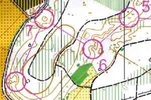
The Double Dumpling weekend visited two areas new to me, and the second of which was completely new to orienteering. First up was Ken Hill, a small patch of wood near the coast north of King's Lynn, covering a long flat-topped spur. While the finish and assembly area were down on its north side, the start was thoughtfully placed up on top to save us an immediate short sharp climb. Although it was a bit brambly in places, the southern part of the area was generally runnable and had some nice contour features. Most of the course was out and back through this, and it was only towards the end of the course that we crossed back over to the north side of the hill for the last few controls on the flat. Though I'd been overtaken by a few runners on the paths, my only mistake was ending up at the wrong end of the pond at control 4, and when finishing in just over an hour I thought I must have done reasonably well. Second was probably better than I deserved though, as it was well behind Glen's winning time.
NOR Dumpling Badge Event
Hockham North (Norfolk)
- Planner: Graham Wardle
- Course: M21S, 8.4km, 40m
- Result: 72:16 (3rd of 12)
[winner Glen Richardson (NOR) in 61:43] - More info: here
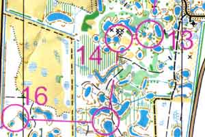
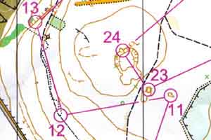
Hockham the following day was a bit of an unknown quantity, though there was a hint of what might be in store from the geological note about pingo ponds in the final details, and the descriptions which revealed five of my last six controls to be on ponds. It was also the East Anglian Championships, though this didn't mean too much since I'm still running short courses... While on the way to the start there were several comments from earlier finishers along the lines that it was an "interesting" area. My first control was a pond as well, though nothing out of the ordinary - the first half of the course was all through typical Thetford plantation, mostly light green with little undergrowth to worry about, and barely noticeable point features such as the 20cm high "knoll" for number 3. There was a longish track run from 9-10 heading over to the eastern part of the area, which gave me a good opportunity to study the second half of the course - and I needed it!
The main area of pingo ponds, shown in the map extract above, was unlike any area I've ever been to - generally flat but littered with an irregular jumble of ponds and ditches. There were plenty of fallen trees around too, so it wasn't always possible to just go straight. I was probably a bit lucky, but managed to keep track of which pond was which and hit the controls spot on. The ponds led most of the way back towards the finish, so I was relieved not to have wasted time there, and interested to see whether others had been so lucky. Although I was a place lower than the previous day, I was closer to the winner's time (Glen again) which is encouraging with the JK coming up. Well done to NOR for organising an excellent weekend.
14th March 2004
EAOA CompassSport Cup
Warren Wood (Norfolk/Suffolk)
- Responsibility: Planner
- More info: here
EAOA hosts a regional round of the CompassSport Cup every other year, and unlike other regions who delegate it to one of their clubs, the event is organised centrally with each club contributing manpower to one area. The down side of this arrangement is trying to find an area and the major officials, which can be left a little late. My last significant planning was the same event at Highlodge Warren two years ago, at which everything possible seemed to go wrong. The root of most of the problems was foot & mouth, as everything was originally in place for March 2001. By the following year the map was out of date - my original courses were useless, and convoluted planning using the only parts still acceptable meant that the start was about 2km away; the weekend before the event, an enduro motocross event created several huge new paths in the area just after the start; and someone accidentally programmed the finish boxes to turn off about half an hour after the last start...
Anyway, despite all this I ended up planning again, largely as a result of being the only volunteer, and was only appointed in January. Thanks to John Ward, agreeing to add yet another event to his controlling schedule, we had a team that had worked together twice before, and the short notice didn't cause too many problems. With help from Blanka most of the controls were put out the day before, and on the day everything went remarkably smoothly in contrast to two years ago - all the elements of organising ran efficiently despite the wind threatening to blow the download tent away, nothing went wrong with the controls, and I ended up feeling rather redundant!
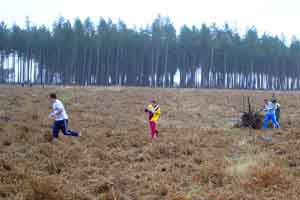
As for the area and courses themselves - I'd mapped the area for a badge event last January, so the main task was to enlarge it to 1:10k for clarity and update a few recent bits of felling. Knowing the area well meant I could choose the finish area before visiting again, in this case a wide ride with a good view of the felled area through which all the courses finished (the rootstock in the photo is one of the late controls). The Men's Open, at 10.5km long, visited nearly all the area but without significant repetition. Other courses were planned to maximise use of the only two interesting areas on the map, unfortunately too far separated for courses 4 and below to visit both. As expected, there were some very fast flat-out speeds achieved by the course winners. As far as I could tell most people enjoyed them, but if you ran here and didn't I'm open to your suggestions as to why.
Overall, based on this experience, two months to prepare is better than eighteen - last-minute addicts around the country rejoice :-)
7th March 2004
WAOC Colour Coded
Warden Warren (Bedfordshire)
- Planner: Norman King
- Course: Brown, 7.2km, 125m
- Result: 54:59 (21st of 33)
[winner Rolf Crook (WAOC) in 40:06] - More info: here
This was the last EAGAL of the spring, and probably a new venue for a round of that competition. Firstly I need to thank John Ward for coming to the rescue when CUSU screwed up yet again, otherwise I wouldn't have got there at all. Warden Warren is pleasant, runnable, contoured woodland, but it is also small with the map comfortably fitting onto A4 at 1:7500 - this despite the addition of some more open fields to increase the available area.
When I picked up my map, I was quite surprised that the whole course was on one side, since the blue course of my previous visit had needed a second map. The course crossed itself twice, but actually was still quite clear, although the control circles were shrunk to just 3mm diameter. The first control illustrated the importance of watching the previous runners on your course start, which as luck would have it I couldn't do on this occasion as there were no other brown runners around. This was because despite the start layout pointing southwest towards the forest, the first leg actually left east through the field...
Although the parkland bits were easy and a bit dull, most was in the middle of the course which made a couple of nice changes of terrain type and was good use of the area. The only real mistake I made was while heading up the hill to the depression at control 11, when I passed it to the right. Another runner was a little way ahead of me and too far left, and somehow we managed to pass either side! The only other trouble I had was getting from the last control to the finish, where there was no sign of the mapped gap in the bushes, and I ended up going down to the road. This was probably the first time I've been under an hour for a brown course, though as Rolf's winning time of 40 minutes shows it was quite short due to the small area. If only the forested bit was four times the size :-)